How to look for records of... International boundaries
How can I view the records covered in this guide?
How many are online?
- None
1. Why use this guide?
The National Archives has one of the UK’s richest archival collections of material relating to international borders, referred to more often in the records held here as international boundaries.
This guide will help you to find maps and many other kinds of records of international borders within our vast holdings, providing historical context for borders around the globe, some dating back centuries, others from recent decades.
Many international boundaries remain in dispute today. The resolution of such disputes often depends on records of earlier definitions, demarcations and surveys. As time has passed, archives in many countries have been destroyed by war, natural disasters or major changes in government. As a result, documents at The National Archives often constitute the sole surviving record of earlier boundaries and boundary surveys.
2. What kinds of records do we hold?
The National Archives holds the records of UK central government which have been selected for permanent preservation.
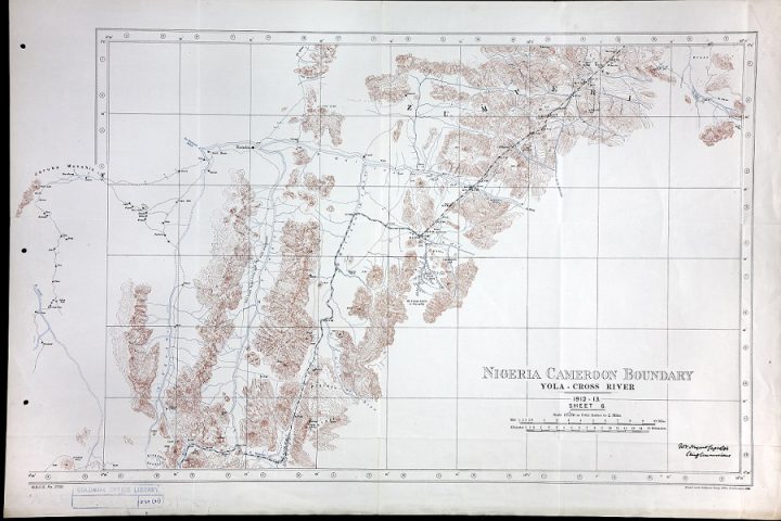
One of a number of Colonial Office maps from 1912-1913 showing the Nigeria Cameroon boundary at the Yola Cross River (catalogue reference CO 1054/175). The Colonial Office is among the past government departments that collected large numbers of records of international boundaries, since transferred to The National Archives. You can order a high-resolution copy of this image from our Image Library.
2.1 Where our records of boundaries come from
The practice of accurately surveying and mapping international boundaries did not become the norm until the 19th century. Boundaries between British and neighbouring colonies of other European nations were often defined by treaty and then mapped out by an international boundary commission. Even when Britain had no direct interest in the territories affected there was frequently a British commissioner on international boundary commissions, such was the high regard in which British surveying expertise was held internationally. The records generated by these surveys were usually deposited in the archives of the countries concerned but a certified copy was often brought back to London by the British commissioner and invariably deposited among the Foreign Office archives.
It is among the records of the Foreign Office and the other government departments responsible for handling foreign affairs and British interests overseas that you are most likely to find documents relating to international boundaries at The National Archives. The most significant among these past and present departments are:
- The Foreign Office
- The Foreign and Commonwealth Office
- The Dominions Office
- The Colonial Office
- The War Office
- The Cabinet
- The pre-1782 Secretaries of State
We also hold the International Boundary Archive of the Ordnance Survey International Library.
Other sets of records held here that contain information about – and maps depicting – boundaries are the private papers of a relatively small number of high-ranking civil servants, politicians and military officers who were involved in boundary making (see section 4 for examples).
2.2 Record types
The National Archives has an especially rich collection of maps but records of boundaries extend well beyond just maps. Document types include treaties, official reports by boundary commissioners, diplomatic despatches, survey data, memoranda, cahiers de specification (containing the technical specifications needed for the marking out and drawing up of boundaries) and photographs.
The chances of records existing is increased where there has been a boundary dispute at some point in the past.
3. How to search for records
The vast majority of these records are not available to view online. To view them you will either need to visit us to view the originals in person or order copies by first finding document references.
3.1 Getting started: broad searches
Use our catalogue to search for document references. Once you have a document reference you will find instructions in our catalogue for how you can view that document. The following keyword searches will return search results for maps and other records concerning boundaries:
- ‘boundary’ or ‘border’ and the name of a country or territory
- ‘frontier’ and the name of a country or territory
- “Boundary Commission” and the name of a country or territory
- “Boundary Commission” and the name of a boundary line, such as Turco-Persian or Austrian-Yugoslav
- ‘border’ and the name of a borderline, such as Syria/Israel border
A note on terminology: the word ‘boundary’ in this context occurs more frequently in our catalogue than ‘border’. We therefore use ‘boundary’ as the main term in this guide but consider ‘border’ to be a synonymous term.
3.2 Drilling down further: target records of specific departments
Using the same, or similar, keyword search terms suggested in 3.1, search across The National Archives departments most likely to hold maps and other records of international borders, as listed in section 2.1. It may be worth starting with the International Boundary Archives of the Ordnance Survey International Library but other key series are among the records of the Foreign Office, Colonial Office and, for records before 1782, State Papers record series. Some of the most significant series in these departments are listed in the table below. They contain various types of records, including:
- treaties and records relating to treaties
- correspondence
- confidential print (many of which contain printed versions of boundary maps)
- the archives of British embassies and consulates
- the archives of British High Commissions (these are among the records of the Dominions Office and its successors – from 1925 the Dominions Office handled semi-autonomous territories such as Canada, Australia and South Africa and some anomalous territories such as the ‘High Commission territories’ of Botswana, Lesotho and Swaziland)
For more in-depth advice on these record types and how to locate them see our guides to Foreign Office records, Colonial Office records and State Papers Foreign.
Each series in the table below covers material relating to numerous countries and regions. Click on the series reference and search the series using the kinds of keywords listed in section 3.1:
| Records series | Details | Series dates | Series reference |
|---|---|---|---|
| Dominions Office and Commonwealth Relations Office: Original Correspondence | This series includes reports, including some maps, regarding the boundaries of and maritime borders of India, Canada, Australia and New Zealand. | 1915-1971 | DO 35 |
| Part one of the principal collection of maps accumulated by the Colonial Office | Includes numerous maps of boundaries of British colonial territories. | 1595-1927 | CO 700 |
| Part two of the principal collection of maps accumulated by the Colonial Office | Includes numerous maps of boundaries of British colonial territories. | 1779-1947 but predominantly 1910-1940 | CO 1047 |
| Part three of the principal collection of maps accumulated by the Colonial Office | Includes numerous maps of boundaries of British colonial territories. | 1897-1984 but predominantly after 1940 | CO 1054 |
| Marine and Transport Department: Registered Files | Includes reports on disputes and arbitration concerning various maritime boundaries, including: the Channel Tunnel jurisdictional boundary; UK Continental Shelf boundaries; UK fishing boundaries and the maritime boundaries of British overseas territories or former colonies. | 1961-1982 | FCO 76 |
| General correspondence of the Political Department and other departments | The Foreign Office bound much of its general correspondence relating to maps of various parts of the world in a separate series of Library ‘cases’. This series also contains information about map production, accuracy, printing and distribution. | 1745-1975 but mostly pre-1906 | FO 83 |
| Protocols of Treaties | Many treaties contain maps showing a boundary as envisaged during negotiations but before demarcation on the ground. There is a typescript Index to Important Treaties 1635-1913 in the reading rooms at The National Archives. | 1695-2003 | FO 93 |
| Foreign Office miscellanea | 1639-1950 | FO 95 | |
| Foreign Office miscellanea | c1700-1953 | FO 96 | |
| Foreign Office general correspondence | 1906-1966 | FO 371 | |
| Foreign Office Treaty Department correspondence | 1906-1967 | FO 372 | |
| Foreign Office Maps and Plans | The principal collection of maps accumulated by the Foreign Office. It includes numerous maps of international boundaries in the demarcation of which Britain played a role. | 1700-1944 | FO 925 |
| International Boundary Archive of the Ordnance Survey International Library | This collection contains international boundary survey data, maps, correspondence and files. | 1879-2003 | OS 62 |
| Treaty papers in State Papers Foreign | 1577-1780 | SP 103 | |
| Treaties | State Papers Foreign series (there is a typescript Index to Important Treaties 1635-1913 in the reading rooms at The National Archives). | 1579-1780 | SP 108 |
| Directorate of Military Survey papers | There are many papers relating to boundary surveys of former British colonies in the records of the Directorate of Military Survey. | 1887-1985 | WO 181 |
As well as records of the State Paper Office, Foreign Office and Colonial Office, the minutes, memoranda and conference papers of the Cabinet and its numerous committees contain many maps of international boundaries. Such maps were usually printed at a small scale to illustrate discussion papers or to provide background information. For more advice on these records and how to find them see our guide to the records of the Cabinet and its committees.

A Colonial Office map of the division line between North and South Carolina in 1730 (catalogue reference CO 700/CAROLINA8). You can order a high-resolution copy of this image from our Image Library.
3.3 Search in country- or region-specific series
Use the tables in section 4 to find a series specific to the country, region, boundary or border you are interested in.
4. Selected series by country, region or subject
The following record series all contain maps or other records of international boundaries in the regions indicated.
Although the Colonial Office was responsible for administering the colonies of the British Empire, it was the East India Company and subsequently the India Office that administered the Indian sub-continent and a number of other territories east of Suez. These records are held at the British Library.
Click on the record series references below and search the series using keywords (see section 3.1 for some suggested keywords).
Ireland
| Records series | Series dates | Records description |
|---|---|---|
| CAB 61 | 1924-1925 | Records of the Irish Boundary Commission |
| CO 537/1072-1110 | 1925 | Printed records of the Irish Boundary Commission within Colonial Office confidential print, covering conference proceedings, reports and memoranda |
| HO 267 | 1900-1932 | Records on the Irish Boundary Commission among the correspondence and papers of the Imperial Secretary to the Governor of Northern Ireland |
Africa and the Middle East
| Records series | Series dates | Records description |
|---|---|---|
| FO 83 | 1745-1975 but predominantly pre-1906 | Foreign Office Library ‘cases’ which include maps of boundaries in the former Ottoman Empire after 1878. |
| FO 367 | 1906-1913 | General correspondence from the Foreign Office’s African Department (correspondence after 1913 is in FO 371). |
| FO 633 | 1840-1929 | Material about the Rafah-Aqaba Line (the southern border of Israel with Egypt) in the papers of Lord Cromer. |
| FO 800 | 1824-1968 | Material about the Rafah-Aqaba Line (the southern border of Israel with Egypt) in the papers of Sir Edward Grey. |
| FO 867 | 1903-1971 | Records relating to the administration of Anglo-Egyptian Sudan. Includes minutes and correspondence, 1931 to 1954, relating to the Darfur-Wadi boundary. |
| OD 6 | 1939-1990 | Files of the Directorate of Overseas Surveys. Contains a small number of files about the Kenya-Ethiopia boundary. |
| WO 181 | 1887-1995 | There are many papers relating to boundary surveys of the Middle East and North Africa in the records of the Directorate of Military Survey. |
The Americas
| Records series | Series dates | Records description |
|---|---|---|
| CO 6 | 1816-1868 | Colonial Office correspondence on British North America. Includes papers relating to the boundary between British North America [Canada] and the United States of America pursuant to the Treaty of Ghent; and report of Commissioners appointed under the Treaty of Washington (1848 to 1850). |
| FO 83 | 1745-1975 but predominantly pre-1906 | Foreign Office Library ‘cases’ which include a number of papers about maps of the boundary between the United States and Canada. |
| FO 96 | c1700-1953 | Foreign Office miscellanea which includes financial accounts relating to the North American Boundary Commission 1843-1848. |
| FO 302 | 1872-1876 | Archives of American North-West Boundary Commission. Includes an album of photographs of the Commission at work. |
| FO 303 | 1796-1829 | Archives of American Treaty of Ghent Commission. |
| FO 304 | 1796-1812 | Archives of American Claims Commission, 1794.
Includes discussions of commerce and navigation between Great Britain and the United States to decide on the identity of the River St Croix named therein as a boundary line. |
| FO 928 | 1965-1967 | Argentine-Chile Boundary Arbitration |
Asia
| Records series | Series dates | Records description |
|---|---|---|
| CO 129 | 1841-1951 | Hong Kong, Original Correspondence. Includes reports, photographs, maps and plans relating to the ‘New territories’, 1899-1949 |
| CO 874 | 1865-1949 | British North Borneo Company papers. Include correspondence and reports and copies of treaties and conventions regarding the Anglo-Dutch boundary between British North Borneo and the Dutch East Indies. |
| CO 1069/452 | 1898 | Colonial Office Photographic Collection: Photographs relating to the work of the Chinese and British Boundary Commissioners delimiting the New Territories |
| DO 133 | 1946-1971 | High Commission and Consular Archives, India: Registered Files. Includes files relating to the boundaries between China and India, and India and Pakistan, including disturbances in Bengal and Punjab arising from Boundary Commission awards in 1947. |
| DO 196 | 1960-1968 | South Asia Department: Registered Files. Some files relate to border incidents and boundary disputes regarding India, Pakistan, Afghanistan and Burma. |
| FCO 40 | 1965-1989 | Hong Kong Departments, registered files. Contains documents relating to the future of Hong Kong and its boundaries |
Europe
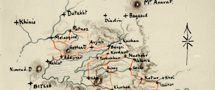
Cross section of a Foreign Office map showing the Armenian-Turkish border in 1908 (catalogue reference FO 195/2283). You can order a high-resolution copy of this image from our Image Library.
| Records series | Series dates | Records description |
|---|---|---|
| CO 926 | 1938-1966 | Mediterranean Department: the registered files include reports on boundaries between Spain and Gibraltar, and Sovereign Base Areas in Cyprus |
| FCO 27 | 1967-1968 | Mediterranean Department: a continuation of the registered files from CO 926 |
| FCO 42 | 1967-1971 | Gibraltar and South Atlantic Department: there are some papers relating to Gibraltar’s maritime boundary in this series |
| FO 32 | 1827-1905 | Greece original correspondence: contains papers of Lieut-Col G. Baker of the Greco-Turkish Boundary Commission, 1830-1834 and of the Frontier rectification boundary Commission, 1881. Greco-Turkish Boundary Commission archives, 1832-1833 may also be found in FO 97/232 |
| FO 78 | 1780-1905 | Ottoman Empire original correspondence: includes reports from the Eastern Roumelian, Bulgarian, Serbian and Montenegrin Boundary Commissions, 1879-1879 |
Wartime and post-war boundaries
| Records series | Series dates | Records description |
|---|---|---|
| FO 373 | 1918-1919 | Handbooks prepared by the Historical Section of the Foreign Office for the use of officials attending the Paris Peace Conference of 1919 to 1920. Many contain maps illustrating the history of international boundaries under consideration at the end of the First World War. |
| FO 608 | 1918-1920 | Correspondence and papers of the British delegation at the Paris Peace Conference of 1919 to 1920. Includes numerous files about the boundary changes following the end of the First World War. |
| FO 893 | 1920-1924 | Ambassadors to the Peace Conference: minutes of proceedings. Includes reports and details of expenses, appointments and associated documents for the various boundary commissions established under the treaties of Versailles, Sevres, St. Germain-en-Laye, Trianon and Neuilly. |
| FO 1049 | 1943-1951 | Records of the Control Commission for Germany (British Element). Includes maps of boundaries between the British Occupation Zone and neighbouring countries, and of inter-zonal boundaries. |
| WO 106 | 1837-1962 but predominantly post-1870 | Correspondence and papers from the Directorate of Military Operations and Intelligence. |
5. Maps, documents and other resources elsewhere
The IBRU Centre for Borders Research at the Department of Geography of Durham University is one of the world’s leading research centres on international boundary making and dispute resolution.
A number of other institutions have significant holdings of maps relevant to studies of international boundaries. Particularly of note are:
6. Further reading
All of the recommended publications below are available in The National Archives’ Library at Kew. Some may also be available to buy from The National Archives’ shop.
John B Allcock (ed), Border and Territorial Disputes (3rd edition, Harlow, 1992)
Louise Atherton, ‘Never Complain, Never Explain’: Records of the Foreign Office and State Paper Office 1500-c1960 (PRO Readers’ Guide No 7, PRO 1994)
Mandy Banton, Administering the Empire, 1801-1968: A Guide to the Records of the Colonial Office in The National Archives of the UK (Institute of Historical Research and The National Archives, 2008) – this title is also available from our shop
Ian Brownlie, African Boundaries: A legal and Diplomatic Encyclopaedia (London, 1979)
Edward Hertslet, The Map of Europe by Treaty, 1814 to 1891 (4 volumes, London, 1875-1891)
Edward Hertslet, The Map of Africa by Treaty (3 volumes, London: 2nd edition 1896, 3rd edition 1909) – also available through HathiTrust Digital Library
Michael Roper, The Records of the Foreign Office 1782-1968, Public Record Office Handbooks No33 (Public Record Office, 2002)
List of Colonial Office Confidential Print to 1916 (PRO Handbook no 8, HMSO 1965)